Sunday, June 22, 2014

6-20-14 Ottertail Tornado-Warned Storms

As I sit here this Sunday afternoon after tending to my garden, doing some yard work, and starting to clean out the chase vehicle after a very busy week, I looked at radar and ventured down south.  While up here in the Red River Valley we are currently dealing with too much water, down south, many of my Oklahoma and Texas friends are dealing with some very long term, very damaging drought.  Up here, we have more than enough.  Down in Pawnee, OK, they are so close to running out of water, the city is having to drill emergency wells in order to supplement their water supply.  In Minneapolis, there are road closures, people sandbagging, and even 35W is getting an emergency dike put up due to the rising waters.  Just interesting how weather works.

Now, back to the reason everyone came....pictures!

On Friday, I was sitting in my office at the day job, and chatting with a coworker in Texas.  Next thing I know, I get an alert popping up on my phone saying this:

000
WFUS53 KFGF 202018
TORFGF
MNC027-167-NDC077-202100-
/O.NEW.KFGF.TO.W.0010.140620T2018Z-140620T2100Z/

BULLETIN - EAS ACTIVATION REQUESTED
TORNADO WARNING
NATIONAL WEATHER SERVICE EASTERN ND/GRAND FORKS ND
318 PM CDT FRI JUN 20 2014

THE NATIONAL WEATHER SERVICE IN GRAND FORKS HAS ISSUED A

* TORNADO WARNING FOR...
  SOUTHEASTERN CLAY COUNTY IN NORTHWEST MINNESOTA...
  NORTHERN WILKIN COUNTY IN WEST CENTRAL MINNESOTA...
  NORTH CENTRAL RICHLAND COUNTY IN SOUTHEAST NORTH DAKOTA...

* UNTIL 400 PM CDT

* AT 316 PM CDT...A SEVERE THUNDERSTORM CAPABLE OF PRODUCING A
  TORNADO WAS LOCATED NEAR WOLVERTON...AND MOVING NORTHEAST AT 25
  MPH.

  HAZARD...TORNADO.

  SOURCE...WEATHER SPOTTERS REPORTED FUNNEL CLOUD.

  IMPACT...EXPECT DAMAGE TO MOBILE HOMES...ROOFS AND VEHICLES.

* THIS DANGEROUS STORM WILL BE NEAR...
  BAKER AROUND 340 PM CDT. 
  BARNESVILLE AROUND 350 PM CDT. 

And I quickly look at radar and go "Hrm...this could be interesting."  Not long thereafter, I get a message from my manager asking when my live video feed would be up.  I ask her then "Is this permission to leave a little early today?"  I love my dayjob.

Right away, I get a text message from Robert Hahn at the station wondering what my plans were.  Since he worked the early shift for Mick since he's on vacation, I ask him if I should pick him up.   Within 10 minutes, we were loaded up, and ready to go!

As we started to approach the storm, we would already see the wall cloud with lots of action underneath it.  We just wanted to get to an area where we might be able to get a view of the bottom of the cloud.


View from I-94

Lots of scud action and upwards rising motion into this storm.

Once we were able to get off the Interstate and started working some country roads, my knowledge of lakes country was going to be put to the test.

Pretty disorganized.
Now that we were on roads where we could stop, look, and film, it was time to enjoy the fact we were on a tornado-warned storm.

Same photo as above, just with much wider angle lens. 

What was clear to us is that this storm meant business.  It was in an environment where it could produce a tornado at any given time.  We were lucky enough to have some pretty good cell coverage in the areas we were in so we could bring what we were seeing back to the station.  It was also pretty awesome to have Robert with me to help with things like navigation, radar, and adjusting the streaming camera.


This photo was taken right after it produced a very pronounced funnel over Ottertail lake.  As soon as we saw it produce this funnel, we called into the station and got right on the air.  I was nervous for all my friends out there on Ottertail, and especially my favorite eatery on Ottertail lake.  But more on that later.


When this storm passed over Ottertail, we noticed the storm really started to fall apart.  Both Robert and I wondered if there was some interaction with Ottertail lake which helped the storm lose some of it's punch while it passed over the cold waters.  Might just be a coincidence, but it was fascinating to say the least.

After this point we got closer to Deer Creek, and took a few shots:

Nice rain foot!


Happy Robert.

Once we made our way into Deer Creek, and the edge of our viewing area, we noticed there was a TON of hail still on the ground.


Most of this hail had been sitting there for a little while and it was still over an inch in diameter.  We did see lots of leaves down in the city of Deer Creek, but thank goodness no major damage.

On our way out of town and back to Ottertail, we could see the culverts were just overflowing with water.


And, we even saw a 'multi-vortex tornado'!.  And I use that term loosely.


We then started the long way back to Fargo.  But, since we were so close to Zorbaz on Ottertail Lake, Robert and I did the only sensible thing.

Stopped for dinner.

Geno'z Burrito. 

Great food, reasonable price.  And the fishing on Ottertail Lake isn't bad either!


Good news is as of 6/22/14, no confirmed tornadoes yet from the Ottertail County storm.

One of the questions I was asked over Facebook was why is it so hard to get pictures from lakes country back to the station?  Great question, and thank you for asking!  One of the biggest issues you run into in lakes country is the trees and the hills and the lakes.  All the things which make lake country great, also makes it very hard to spot or chase severe weather.  It's entirely possible for you to be under a tornado warning and not know it because of the lack of cell coverage in the area.  Both Robert and I use different providers for cell service, and even we found it hard to maintain coverage.  In my chase vehicle, I even use cell amplifiers and I was having trouble.  If you are in lakes country, I really encourage you to get a weather radio.  You never know when you might need it.  Just imaging if this storm came through on a Saturday afternoon.  Having a weather radio would be handy.  Two things to have with you if you go to lakes country - VNL StormTeam Weather App, and a weather radio!


Saturday, June 21, 2014

6-18-14 Dickey County, ND and Brown County, SD Severe Storms

This was the second Wednesday in a row I ended up chasing.  Another day, another trip to good o'l South Dakota.  This was also the day of the very destructive tornadoes in Wessington Springs.  I wasn't able to make it all the way that far south and back in one night, so I stuck to the northern storms.  I have to say while I wasn't rewarded with a tornado, I was still rewarded with some pretty awesome structure shots.


One of my biggest challenges for this day was since I was already in Brown County, SD would be to get north to the storms in far southern ND.  I was going in and out of cell signal which made feeding video back to the station difficult at times, and made it even hard for me to call the station and talk to Hutch and Lisa!

This photo was taken looking northwest towards Ashley, ND.  Somewhere in there would be the tornado. 

Another shot. 

Once I was able to get to Forbes, ND, I got a little north and ended up taking this panoramic shot of the shelf cloud, which stretched almost from horizon to horizon.


Somewhere near Monango, ND. 

Somewhere north of Forbes, ND
Quite a good day chase wise, but not a great day for many other people.  We have received so much rain here in ND and SD in the last month, the rivers are I think higher than they were with the spring melt.

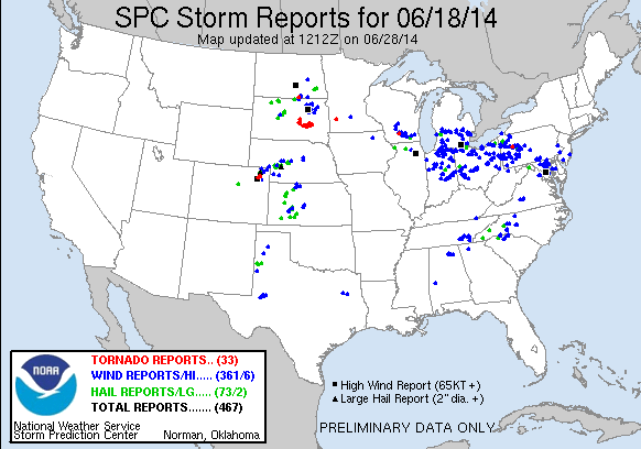
That said, here's the storm reports from this day:


Quite a day.....

6-11-14 Marshall County SD Tornadic Storm

Quite an interesting day!  There was this little storm in Marshall County, SD which went from Tornado Warning to nothing in about 3 scans.  Never saw the tornado, even though I went through what I thought the 'damage' path would be.

This was also the first of two Wednesdays in a row where I would be chasing.  This storm was a little interesting, as I was sitting in Lake City considering punching the core on this storm, I look at reflectivity and really start to re-think that idea.  I also end up getting a call from Lisa Green over at VNL telling me to really be careful because this storm looked very impressive on radar.

It was fascinating on this storm how in three scans it would go from looking like armageddon to hardly a rain shower.  Bring on more 2014 weirdness!

This was also a sad day for me, as after this I went back to Fargo to attend Hope Hanselman's going away party for her and her fiance, as she had taken a job in South Carolina.  Hope is a wonderful anchor, and I always looked forward to working a show with her.  Always relaxed, and I really loved the chemistry we had when we did a show together.  Hope is a great anchor and reporter, and I know she's going to flourish at her new station.


Rainbow at the end of the storm. 

Beautiful evening behind the storm!
Marshall County at rush hour. 


Little did I know, this day would be the start of a number of busy days coming up for me.  The severe weather season was starting to come into full swing here in the upper plains!


Friday, June 6, 2014

6-5-14 Cass/Ransom County Tornado Warned Storms

So first of all, I have to say a BIG thank you to someone for letting me go chase today.  So, uhm, THANK YOU mysterious person!  :)

Now, this was a day which I got up, looked at the HRRR, and said "yeah, we're going to see some pop up storms today.  Maybe a few hailers."  Robert Hahn on the other hand, said at about 1pm "The non-supercell tornado parameter looks interesting in ND today."  Note to self, listen more to Robert, because boy, was he right!  Right around 4pm, we saw our first tornado warning show up for Cass County.  And, I was out the door like a flash. I think between door to chasing was all of 4.5 minutes.  Not that I was counting, but it helps when you keep your summer 'go bag' ready at all times.

I was off for Casselton as quick as I could, while Ashley Bishop and Matt Moore were already off covering the storm.

Once I got a little south on 18, I was treated with a really nice rotating wall cloud.  Too bad I was on the wrong side of it, and got a ton of rain and hail so nothing turned out.  Boo for being late to the party.

I kept party rocking on though, and got a little south and got out of the core and was treated to this on the leading edge.  You can see the precip core off to the right.
Lighting anyone? 


During this entire time, the storm was tornado warned.  The wall cloud I had previously seen had gotten eaten up on the backside and totally fell apart, but this did not mean the storm was totally done.

Better shot of the leading edge.

The storm started to gain strength again, and as I went south, I went through the town of Leonard, and went west a little bit.  I could tell from my radar updates things were starting to get a little more interesting.  I also could tell the storm was starting to get much more organized, and I knew where the action area most likely would be.  This meant giving up some road options in the event something happened, but I knew I still could be safe if need be. And here's why:

HELLO WALL CLOUD. 
This is a textbook North Dakota wall cloud.  Hi there!  Precip off to the right, with the updraft area starting to get cranking.  This wall cloud was rotating and spinning quite nicely.

Mmmm...wall cloud up close and personal. 
Yep, and it started to get it's act together.  While I was sitting here, someone came up behind me.  And it just so happened to be this guy.

Some unknown Kansas guy in front of a wall cloud.  To that I say, BOOMER SOONER!
I know he works for 'the other guys', but it's nice to know even though we compete against each other, we were able to watch the storm and chat about weather for a bit.

It was while Aaron and I were talking that things REALLY got cranking.  The inflow into the storm started to pick up to the point of where the trees were bending over, and we could see the inflow into the wall cloud start to pick up.  Would we see something today?

More wall cloud....and then?


Yep, we would.
If you look to the center of the main wall cloud, you can see a little needle-shaped thing sticking out.  That is called a funnel cloud, the precursor to a tornado.  Yes, the inflow was cranking.  Yes, this wall cloud was rotating.  Did I call the NWS?  You bet I sure did.

Another shot of the wall cloud.  You can see the inflow off to the right, and the RFD cutting in behind it. 
While this wall cloud was cranking away, we started to get some precip in here.  It sure left an interesting feature.  Hutch and I talked a long time last night about what this feature was, including looking at video, speeding the video up, looking at it in real time, and whatever it is, it sure looks like a neat little feature.

Hrm...I vote downburst.


Maybe not my brightest move of the day. 
Once the wall cloud started to surge south, I knew it was time to get out of the way.  The VIL's on this thing had spiked to over 70, and the hail marker was getting bigger.  Yep, time to get east.


At one point here, the updraft was so strong, it was sucking up the precip off the field and pulling it into the updraft.  This means we had some strong inflow just cooking into this storm.  Not many times have I seen a storm suck stuff up like this and not produce.  I tried to go east, but the hail started to get a little large for my liking, and I ended up backing off.  I think this was a pretty good idea, as I didn't feel like explaining why I needed a new windshield to someone.

Once the storm got south of 46, it started to lose strength quickly.  I was at least treated with a nice rainbow to end my day!


Overall, a pretty good chase for short notice.  One thing I did notice is there were a number of other spotters/chasers out on the road, many more than I have noticed in years past.  I'm not sure why on this storm, if it was just because it was Cass County, or just because it was close to Fargo, or people are now getting more excited about weather.  Either way, it was good to see everyone respectful of everyone else, no one driving poorly, no traffic jams, etc.  To all of our viewers on VNL, thank you for tuning in and watching all of us work to bring you your severe weather coverage.  Thank you for trusting us to help keep you and your family safe.  As we get into the heart of severe weather season for the valley, I hope you continue to tune in.  I know I couldn't be more lucky and blessed to work with such a dedicated and hard working group of folks, from Hutch, Robert, Lisa, and Mick, to our awesome news staff and management, to our production and camera operators.  We're really a team over at VNL and I feel proud every day I get the opportunity to work with these fine folks.

6-1-14 Stutsman/Barnes County Chase

Apparently Mother Nature decided that she wanted to act up a little over the last week.  Not that I'm complaining, but it would certainly be nice to have some closer t/d spreads.  Just sayin'.

But, act up she did, dropping tornadoes near Jamestown and Casselton.  And of course, since I had nothing else better to do on my Sunday....

Once I got off I-94, I was treated with this nice 'attempt' at a wall cloud.  I say attempt because it was weak.


A few minutes later, it tried to get it's act together just a tad more, including what appears to be a nice look-alike with a rain shaft in there.  Nothing tornadic, just some pretty clouds.

Not long thereafter I talked to Brady Herring, and we went our seperate ways.  I decided to plow deep into the heart of Barnes County, where I was greeted with a shelf cloud.  With something fun going on underneath it.
Uhm, what?
Now, take a look at the dead center of the photo, HIGHLY enhanced and zoomed in.

And this is....what?
Hold your horses - before people get all "WHAT.  IS.  THAT!!!", keep in mind I was a LONG ways away from this storm.  Also, it was behind trees.  I have no idea what that feature is.  99% chance it's all scud.  I believe it's in the wrong place for it to be what many people think it might be.  But, I don't know what it was.  So, I did the safe thing, rather than call the NWS or the station and blow things out of proportion, I just watched it.  Sure is a good look alike though!

And a few minutes later?  We see....nothing!
And now the storm started to get a pretty nice looking shelf cloud on it.  Precip core off to the right with some nice cloud-to-cloud lighting brightening up my night.  Pretty storm!

Selfie with a Shelfy anyone?
It was about this time, I did the #selfiewithashelfy pic.  It's a trend started by Bill Doms, and I figure I'd just keep it up.

One last shot....
It was about this time I took one more shot, and then started the long winding road home back to Fargo.

And, we had just a few tornado reports this day in North Dakota.  I think at this point we were either tied or leading Oklahoma with the number of official tornado reports for the year.


A very nice chase, and everything worked as planned.  My new gear is working awesome, and more upgrades are coming!

The question is, would mother nature keep pace and keep things active this week for us?  Oh yes she would!

Sunday, May 25, 2014

Cass County Chase 5-25-14

It's been a pretty slow start to 2012.  I mean 2013.  I mean 2014.  So, yeah, it's been slow the last couple of years for severe weather season here in ND.  And the last couple of days, we've been under a 'See Text'.  You know you are getting desperate as a storm chaser when you start drooling over the possibility of a "See Text".  And guess what?  Yeah, I went out today.  Fully knowing the following: 1.  Chance for tornado was zero.  2.  Chance for even seeing something severe was marginal at best.  3.  Best I could hope for today was maybe some pea size hail and a shelf cloud.  So when you don't set your expectations too high......hey, I'm desperate even to see some cloud-to-ground lightning at this point.

Normally on a day like today, I check the HRRR model to see what it says.  Unfortunetly, something happened today, and the last usable run from the HRRR was from 4z.  Really wouldn't help me out today.  So instead, I went to the station, chatted with Lisa and checked out the latest RPM model we have at the station.  RPM seems to do pretty good at these weather systems in managing precip and estimated radar.  At the station, we are really lucky to have the RPM as a resource in our weather toolkit.  RPM and HopWRF were pretty accurate today, so west towards Jamestown I went.

I made it to Oriska, and I was greeted with my first storm and thunder of the season, but it really wasn't photogenic.

As I made my way east to Fargo, I was greeted with a little more structure to the storm:

Here shelfy, shelfy, shelfy....


And near Tower City, it got even more shelfy!


As it got closer to Buffalo, that's the best it really got.  After that, whatever structure was there just disappeared.  However, all the farmers working in the fields did make for some photogenic opportunities!

Dust coming off a farmer's field.

More dust!


FLY, MY BIRDIES!


Ominous looking, but harmless. 

Farmer tilling with smoke in the background. 
You really have to feel for all the farmers in the area, especially out near Spiritwood and Jamestown.  After a pretty good snowmelt this spring, lately it's been so wet they can't even get in the fields to cultivate or plant.  I know the deadline is coming up for many of the farmers for crop insurance to get their fields planted, so it would be nice if they could get a few days of sunny weather with 10 mph wind to dry the fields out so they can get in there and plant.  Days like today won't help matters any.

As I look into the future, there is a system I'm starting to watch for later on into next week.  Not sure if it will pan out, but it's something we're keeping our eyes on.

On the flip side, it was a very good day to test everything out, including some upgrades, so if you ended up watching the live feed today, you _may_ have gotten a glimpse into said upgrades.  More to come later this year....