Thursday, January 30, 2014

September 18, 2013 Chase

Since it's been a little while again, I went and pulled out some photos from September 18, 2013.  This was an interesting chase.  It was a storm that, while it was severe warned for a little while never really stood a chance of doing much of anything.


One thing I remember was the moon rising this night.  Really made for a pretty background to the storm.


And a little while later as the sun continued to set.


I got sidetracked by the moon rising I almost forgot about the storm!

Awww....nice little eroding base.
Buh-bye now, see you next year!


And that was it.

Once I got home, there was another storm to the north that was tossing off some lightning.  Unfortunately, my lightning-fu was off this night, and my best shot was pretty bad.


If you look at the bottom, you can see the shelf moving in.  Pretty nice, but I figured no one wanted to see the house in the field I was at taking these photos.  That, and I don't want to reveal the field I go to!

That being said, this was really the second to last 'summer convection' chase of the year - with the last one being in October with Lisa.  Also, note to some other chasers who were out there on this storm - SLOW DOWN.  No reason to be driving like maniacs on a non-severe storm.  Your fellow chasers appreciate it.


Sunday, January 12, 2014

Bonus Blog! (because it's quick!) 7-1-08 (Fargo, ND)

Here's a couple of lightning pics from 7-1-08

Apparently this thing was a hail producer out in lakes country.  I tried to figure out why I didn't go after this guy....after looking at my calendars, I believe I had some day-job related commitments the next day.  Most likely.

Either way, enjoy the two quick pics.


Quite the anvil on this guy!

The one advantage on this guy is the total chase miles traveled.....about 25 feet.

Best chases are the close ones, right?

Link to the SPC:

SPC Reports for this day.

June 5, 2006 - Cass County, ND

Since we are in the depths of winter here, and I haven't updated the chase blog in FAR too long, I figured I'd go into my archives and pull something out which makes me think of summer.  Especially since today it was over 40 degrees ABOVE today!  Really isn't much of a story with it, other than "Hey, here's some cool photos!" since it's been a few years.  You'll have to forgive the horrible copyright, etc.

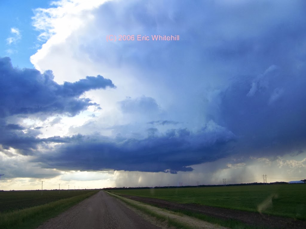
This first pic here is from near Casselton.  Quite the nice day when you see an LP here in North Dakota.  We don't see many of them, so this was very nice for a change.

Mmm...pretty!
Here's a couple more from coming up on the cell.  I took quite the number of photos this day! 


Supercell anyone?
One thing I remember about this chase is how slow this storm moved.  It pretty much just sat there.  I remember watching it going "Wow!  This is just awesome!"  Yeah, it was....

Starting to get it's act together...
I remember listening in on the spotter net this evening and people were calling in stating it wasn't doing anything and they could not figure out why FGF had this storm warned.  I knew why....

HELLO THERE!

Yeah, it had a nice little lowering going on with lots of action.  Yep, if it's not an HP supercell.....


I don't know why but this shot from above just sticks with me.  I think that's why I decided to post this blog tonight.  Even though I don't remember every single detail about this chase, I still remember this photo sticking out in my mind.

All by my seelllllfff....
One thing which this photo that strikes me is that I was all by myself on this chase.  No other chasers out there.  I know those days are pretty much gone now, but I still like to sit back and think of these times when I was just out chasing and I would be the only person on the storm.  I'm not sure days like that will happen much anymore, but I still love being able to do it.


One more shot from the day.

Apparently this storm did have a touchdown, but I never saw anything fully condense.


TimeLocationCountyStateLatLonComments
21456 SSE FORESTBURGSANBORNSD43949806TORNADO VISIBLE FOR 2-3 MINUTES AFTER TOUCHDOWN AT 445 PM CDT. BECAME RAIN WRAPPED BUT APPEARED TO CONTINUE THROUGH 452 PM CDT. DAMAGE UNKNOWN. (FSD)
00358 ENE SHELDONRANSOMND46639734A DEPUTY REPORTED A BRIEF TOUCHDOWN WEST SOUTHWEST OF LEONARD ALONG THE CASS AND RANSOM COUNTY LINE. (FGF)
00352 WSW LEONARDCASSND46649728
A DEPUTY REPORTED A BRIEF TOUCHDOWN WEST SOUTHWEST OF LEONARD ALONG THE RANSOM AND CASS COUNTY LINE. (FGF)

I never saw any touchdowns, but then again I think there were several storms that day.   (edit) Yep, just checked - there were.  I just picked the wrong storm.

Either way, a pretty nice day in June.  And I still think about it 8 year later.  Let's hope I still remember it this fondly in another 8 and 28 years.

At least we aren't -30F right now!


Monday, October 14, 2013

October 10th, 2013 - Valley City to Cooperstown Chase


When you wake up on October 10th and see this as your homepage, you know it's going to be a good day.

After some quick work at the day job, I ran back to the station, discussed things with the rest of the awesome VNL StormTeam, Lisa and I piled into the chase vehicle, and off we went towards Valley City.  I wish I would have saved some of the data from Friday, but alas, I didn't.  There was going to be some very strong shear, but not much for instability.  As a wise meteorologist once told me "Eric, shear can overcome almost anything...don't discount a day just because you don't have much for instability."  This meant the chase was on!

Because we were going to be dealing with low-topped supercells, it was going to be very hard for us to depict anything on radar.  The area we were targeting, the radar beam was going to be fairly high up, which would make it difficult to see any sort of rotation on radar.  Thus, our eyes would be the best thing today to look at storms.

Just outside of Valley City, we were able to get on some storms.  When the first cell came through, Lisa and I could see the wall of rain and wind coming at us.  It was quite the sight to see as you could just see the rain curtains wrapping around the storm as the shelf got closer.  Once it got to us, it dropped some pea size hail and that was about it.


After we let the storm pass us by, we dipped a little south to try to see things on the back side of the storm.  Since it was a tricky day to see the action area of the storm, we had to take some chances with it.  On the back side though, we were treated with quite the view!

Lots of low hanging scud.  Great to fool people on what is a tornado or not!

After watching this line of a few minutes, Lisa and I went further south, as the low was moving to the northeast, there was another line of storms starting to form, and we wanted to pay close attention to these storms as they would be close to the low and have some additional potential. We got quite the treat!


Nice looking scud!

Not much going on here....

We watched and waiting a little, and then we were treated to this:

Good scud action under this storm!  Great Skywarn training material from today!

Not too bad!

Not long thereafter, the storm really fell apart, and we saw another cell starting to take over.  We then went north and while on our way north, we could tell the storm was starting to get a little more structure to it.

After we got further north, I took out a different lens for my camera and captured this beauty: 


Near Rogers, ND we stopped on a hill just to look at the storm a little more.


Lisa also happened to hop out of the truck and we can tell she is always hard at work scanning the skies! 
Lisa, ever vigilant! 


Just north of Rogers, it tried again to get something going, and it did drop a funnel for a very short period of time (of course while I was looking the other way!) and by the time I looked back, there wasn't much left.


Lisa was able to capture one little glimpse of it, so head on over to her twitter feed for the photo.

Overall, a very pleasant chase, and we were able to be home at a reasonable hour since the next day I had some day job stuff to take care of.

Now, it's time to start thinking about snow!  Not really what I am looking forward to, but winter helps me to appreciate the storms and our summers in the valley.  With my day job, I often times talk to people in the southern part of the US, and they ask me how can I live up in North Dakota with the cold winters.  My reply: Come check us out in the summer.  It makes it all worth it!  


Tuesday, September 3, 2013

August 31st - Fun in Lakes Country, MN!

Saturday morning originally I was planning on going to the lakes and doing some relaxing in my boat.  Instead, when I woke up I found this waiting for me.
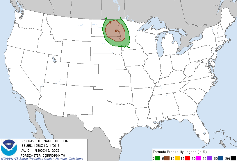
5%?  2013?  Yeah, I'll take that!

Thank you SPC!  Yeah, I ended up not going to the lakes on Saturday.  Instead, I went to the Red River Zoo, checked out the camels and prairie dogs. 


Hey MikeMikeMikeMikeMike!  Guess what day it is?  IT'S A CHASE DAY!

After looking at models and placing a phone call to VNL's own Robert Hahn asking if he wants to tag along (I told him I'd have the OU game on in the car on XM)  we set off on a little jaunt.

South of Barnesville, just across the Wilkin county line we came across this little storm: 


We could tell it was trying to do a 'something'.  

We hung around and waiting for a few more minutes.  What we loved was there was almost continuous thunder around us.  What we didn't like was the number of CG's popping on this thing.  Made us a little nervous being almost the tallest object around.  


As we kept waiting, it got even more interesting.  Too bad it was undercut as hell and going all shelfy on us. 


After this, we needed to get east, which caused us to detour to Fergus Falls.  Just east of Fergus Falls, we came to Wall Lake, which is where we saw quite a bit of damage. 


A homeowner was nice enough to let us see the outside of her house which had some siding ripped off and her shingles lifted and some ended up on the other side of the road.  We also came across a number of downed trees and branches, and even a fishouse which ended up in many pieces.  Pretty strong winds to do that.  We did stop and talk to some folks who were there when the storm hit, and they reported the winds were switching directions - one second out of the east, next it was out of the west.  One thing which stood out to me was the fact the lake and all of these homes were almost at the bottom of a hill steep hill.  It made me wonder if this hill had something to do with the effects of the wind (land propagation I believe is the correct term - someone correct me in the comments if I am wrong.) and the damage it caused.  It made for a good discussion at dinner.  

At the end of the night, Robert and I went to the Applebee's in Fergus for an after chase meal.  On our way back to the station so we could get video ready for VNL 10@10, we were treated with a beautiful sunset with a shot of a storm just north of Detroit Lakes. 


As for SPC reports, there were quite a few!  


One lone tornado report up near Pembina.  Pretty interesting!  

I had one report in there from the damage near Wall Lake. 

0440 PM TSTM WND DMG UNDERWOOD 46.29N 95.87W
08/31/2013 OTTER TAIL MN STORM CHASER
TREES BLOWN DOWN AND TWISTED OFF. SEVERAL SMALL SHEDS OR
FISH HOUSES BLOWN OVER AND AT LEAST ONE HEAVILY DAMAGED
BETWEEN WALL LAKE AND BASS LAKE AREAS.


HI ROBERT!


Hopefully this is not the end of the summer severe weather season!  I'd hate to end the year like this.  I know though with each passing day, the chances of seeing more tornadoes drops.  Now, with school back in session it is time to start thinking about the next season....winter!  It's kind of a sad summer when I am still waiting for my tomatoes in my garden to ripen.  Hopefully they do, because if I get a good crop (and I should!) it's salsa making time with a little ghost pepper!  

Monday, July 22, 2013

McHenry County Tornado Warned Storm - 7-21-13

So yesterday morning I woke up, saw there was a 5% tor risk out for parts of ND.  As of late there really has not been much of anything to chase, and I've been getting rather bored.  After looking at the HRRR and the 4km WRF, I called up Bill Doms, who confirmed that if I wanted to see anything I would be most likely paying the Minot region a visit.

Shortly after I left home, I saw this:

And the text of it included these words:

     "ISOLATED TORNADOES ALSO CANNOT BE RULED OUT...ESPECIALLY OVER THE NRN HALF OF
   ND WHERE HIGHER DEWPOINTS AND LOWER LCLS ARE MORE LIKELY TO BE
   MAINTAINED."

Which pretty much summed it up to me - I'm going way north.  Like, visiting my in-laws in Minot north.

I think it was well worth it.

Nice base with lowering

This storm was tornado-warned as it has produced a tornado north of Granville, ND.  As I was approaching the storm the wall cloud was huge and spinning quite nice.  It's been a while since I've been on a tornado warned storm, so I sat here to basque in it's wall cloud glory. 

One of the things I noted is that the surface winds where I was at was very weak - less than 5 mph, which indicated to me it was probably done producing, but it was still really pretty. 


After this I re-positioned myself further north and east, I was treated to the following.

Hrm....


Beautiful updraft!

McHenry County - I'm lovin' it!  (Sorry McDonalds!)

After this I talked to Lisa back at the station a little and also with Henry Blakes at our affiliate in the Minot/Bismarck area and let them know about my photos I had uploaded to twitter.  I didn't think the storms were really going to really get going again with everything else going on, so I started my way home.  As I got closer to Valley City, I noticed just the beautiful sunset I was getting treated to.  Just amazing. 


About the same time, the storm up in Towner and Ramsey counties started to get it's act together.  Here's what it looked like from where I was at: 


You can just see the top of the anvil from where I was at.  Just amazing - almost 100 miles away and you could still see the lightning and tops of the clouds.  

Very good chase, and just an amazing sunset.  Now if we could only get some more storms and get some much needed rain for the crops, that would be the next best thing!