Wednesday, July 29, 2015

July 17th Britton, SD to Madison, MN chase

Just a warning, this post is fairly pic intensive!

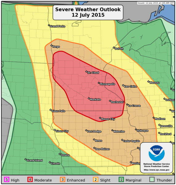
Yet another great day for chasing!  This day started off with me knowing I needed to end my night either at home in Fargo, or out somewhere in Otter Tail County for a family reunion.  Well, I made it to the family reunion, but I was just a tad late.

After leaving Fargo and heading south as fast as I could, I realized we were very capped off in SE ND.  I consulted with the Ministers of Ministers and ended up in NE SD.  We could see the towers going up, and we were starting to get some returns on the ABR (Aberdeen radar).  I had to make a decision - how do I want to attack this developing storm near Britton, SD?  I attack it from one way, there's a good chance I end up in tennis ball size hail.  I attack it the wrong way, and I end up seeing nothing.  So, I decide to attack it head on.

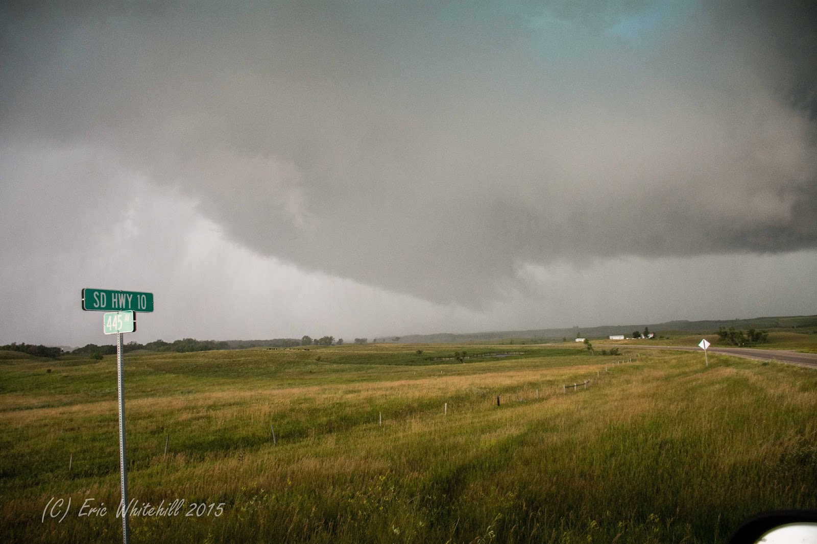
After driving west out of Lake City I ended up just a few miles east of Britton, and boy was I in for a treat.

Why, hello there!

I took over 50 photos of just this wall cloud and feature.  Here's a few more shots:


Shortly after this, the storm started to really get the inflow going.  I could feel the warm air at my back rushing towards the storm.  That was when things got...interesting!

Bowl like feature off to the left? Yeah.  That is what you think it is. 
The wall cloud was just scraping the stuff up off the ground.  You could just see the precip almost get sucked right up off the ground and get pulled in.  It was rapidly spinning at this point and would not shock me to find some damage from it.


I just could not stop taking photos of it.  At some point though, I knew I would have to leave as this wall cloud was starting to dissipate and a new one was starting to form and take it's place.  This is where the new action area and possible tornado would form.  I also knew from spotter reports there was some very large hail being reported with this storm, which I wanted none of as I like my windshield intact.

At this point I moved to the east, making sure I was staying ahead of the hail core or trying to stay in the inflow notch, as the chance for hail and being in the right position to see something spinny would be the best. Being able to do things like this only comes from experience and training, so please, don't try this at home.


Rain and hail core.  Yes, it was loud. 

Hail core to the north of me. 
Looking more outflow dominant...or is it? 


Yummy. 

OH HAI THERE! 

Edited this photo a little so we could see what is going on behind the rain/hail. 
Soon, the new wall cloud started to form and it got it's act together quickly and the storm stayed tornado warned.  I knew I'd need to get east, as the large hail reports continued. 


Just a cool cloud formation along the leading edge...right? :) 
I see the tour groups from COD around, so it was pretty near to know I'm probably in some tour groups photos.  That, and it's always fun to run into.  COD really does a great job educating and taking people on safe tours. 

WHO IS THIS GUY?  I MEAN, REALLY?  SAME ROAD? :-) 
I run into a few other chasers along the way, which was always fun.  I wasn't able to really stop and say hi and gab, as I was very busy getting live footage up to the networks and doing phone cut ins.  So, if I seemed short to some of you out there, I apologize as I was just a _tad_ busy.  

Yikes.
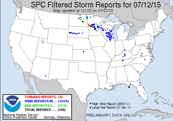
Yikes is a good way to put it.  You could almost feel the hail coming down, instead of the roar.  Every once in a while a golf ball or greater sized stone would come flying out and I'd be greeted with a familiar 'TONK!" on my roof or I'd see it explode on the ground around me.  I knew it was time to get east.  As I made my way east, I also ran into THE Doug Kiesling.  Something about a fireworks and a dirt road comes to mind.  (Inside joke.)  This cell was also Tornado warned (radar indicated) and it would be making a beeline for Sisseton.  I needed to get east...and fast! 

Wall cloud/area of concern is off to the left.  
I made it into Sisseton and parked myself down a little road where I knew I could get out.  I needed to also plan my roads smartly and quickly as I knew very large hail was coming for Sisseton, and I needed to deal with the road network and the ultimate decision - do I go south on I-29, or do I continue to jog east and hope the hail core stays far enough north of 10 to where I don't turn into a gigantic while golf ball.  

As I was heading east out of town I could see the large hail stones falling all around me.  I could also feel every larger stone as it hit my truck.  I knew as I was heading east south on I-29 toward Peever would be my choice.  

Sisseton under the hail shaft right about...now. 
I headed south, took one quick look back, and I could see something trying to make it's way out of the clouds and wall cloud area.  I never saw anything touch the ground though. 

It was also around this time Bill Doms and I ended up chatting on the phone quite a bit while we tried to figure out our attack plan.  I know that Nick and Amanda were making their way towards Ortonville to see shelter from the bow echo which was forming.  I went down by Corona to Wilmot and was greeted with some of the best Stacked Plates I've ever seen. 


Oh, yeah.  Notice the storm off to the left.  That's the next cell coming at me which I would have to deal with!

Just incredible...

I tried to warn her....
Just incredible shots. 

At this point, I was making my way down dirt road after dirt road.  The good news most of the really nasty dirt roads (including some minimum maintenance!) were still in decent shape as they hadn't been hit by the rain and hail yet.  

I kept making my way south and east, but at some point I would have to face the beast and let it overtake me so I could make the final long journey home.  I knew there was no way I would make it to the family reunion tonight.  

I made a few phone calls and after talking to some friends and Hutch back at the station, I ended up finding out about a car wash in Madison, MN.  This is where Bill and I would meet up, get some gas, and then ride out the storm.  

Bill and I ended up riding out the storm, and just before the storm hit, it looked like this: 

Mommy.
We expected to get hit with 70+ mph winds, so we set up our cameras and proceeded to watch the town of Madison get hit by the storm.  We saw the town lose power fairly quickly, but it seemed like the worst of it went just south of the town.  

Bill and I were both able to escape the storm with no damage, aside from a bent Ham Radio antenna, and said our good-byes and started to make our way home - him to Minnesota, myself to Fargo. We were able to chat on the phone for the first hour or two, which is always a welcomed thing.  You know you have a good chase partner and friend if you have someone willing to gab with you about almost anything to help decompress after a chase and to help keep you company on the often times long drive home.  

I ended up getting home right around 1am, after a stop at McDonalds for yet another Minion toy.  (Did you know I have an unhealthy obsession with Minions?) 

I have a few pano pics which didn't make it into the full set from earlier. Here they are in no particular order: 


Overall, a very awesome chase, and a great way to end a day. 

I made it out to the family reunion on Saturday morning and ended up out in my boat for a good portion of the day.  Good times with family, some fish in the fry pan, all said - a pretty good weekend.  And really, isn't that what this is all about?  That said, don't skip out on your family reunions.  Yes, we all have the crazy Aunt/Uncle...but you know what?  You're still going to miss them when they're gone.  Find out about their lives growing up.  You might be surprised about what you find out!  


Friday, July 24, 2015

7/12/15 Ottertail County Tornadoes near Doran, MN and Campbell, MN

So on Sunday morning, July 12th I woke up to this:

201507120759 PWO graphics

Mod risk?  Yep!  I'll take that!  Granted, the moderate risk was for wind damage, as a majority of the models were all indicating storms would fire in far SE ND to Western MN, and then line out and form into a bow-echo and race east.

Thus, a day of chasing was made!  I ended up starting near Whapeton and picking up a little mascot for my day!

Ba ba ba ba na na naaaaaaaa!  Assemble the Minions! 
If you know me outside of chasing, you know I have a fairly unhealthy love of Minions.  It was my hope this little guy might be able to help me with my cameras later today, in the event things got 'interesting'.

Later on in the afternoon after chatting with the Richland County Sheriff, I started to see a cell go up, but it went up north of the area I was targeting.  It quickly became tornado warned, and after following it for a little while (and then some extra encouragement from Bill Doms) decided to drop the tornado warned cell which was quickly going into the trees and dropped back south to where the best chance for seeing a tornado would be.

Cell going up over Whap. 
 I was soon treated to some fun looking clouds near Foxhome.

Not a funnel or tornado - this is just scud rising into the cloud.  Very neat look-alike though and would fool the untrained eye. 
One of the big differences between June 27th and today is that the LCL's would be much lower - this would mean we would most likely see many more "SLCs" or Scary Looking Clouds which would probably increase the number of tornado reports/sightings today and it was something to be wary of.  Even as an experienced chaser you can still sometimes get all caught up in the excitement and be unsure of what you are actually seeing.  I still have to remind myself to be calm, take a deep breath, and then make a good decision.

Looks scary...
Just south of Foxhome, I saw this feature:

Multiple Tornadoes?  No, just the leading edge/sharks teeth. 
While this looks scary, it's just the leading edge.  Sometimes it is called 'sharks teeth' by some chasers.  Not tornadic though.

This on the other hand....

Starting to tighten up! 
This is the wall cloud which would eventually become the Doran tornado.

I was south of Foxhome at this time, and I was constantly trying to outrun the rain and the hail which was just to my north by about a mile.  Every once in a while I would get a larger hail stone around golf ball side chucked out at me.  That would just let me know that it was time for me to start to make my way south to get out of the way.  Around this time I would see people driving north INTO the large hail and rain/wind.  I just hoped no one lost a windshield or two doing this.

After moving to the south and talking to Hutch back at the station the whole time, I was treated to this:


At the time, this storm was not tornado warned.  I was on the air with Hutch at the time and asked him to please relay my report to the NWS in Grand Forks since I wouldn't be able to make the phone call myself.

This funnel/tornado persisted for several minutes.

Yikes!  You could see the rain wrapping up and around. 
More cone-shaped now.  Not like Ice Cream though. 

I was also at this time riding the core - basically trying to stay just ahead of the tornado and just south of the rain/hail core.  It can bring you some good photos, however it can also be a very dangerous place to be if you don't have a good road network.  I'm lucky because I've been around these parts for many years and I knew the road network very well.  One of our viewers (Ashley) happened to capture a photo of Hutch and I live with this feature on the air.  I have to admit, it was pretty neat to see that photo.  I don't always get to see my work on the news since I am usually so busy working.  I've recorded a few of our hits, as we are always striving to get better.

Starting to fall apart a little. 
Soon after I started to get more rain and larger chunks of hail tossed at me and I needed to bail south.
As I got south towards Campbell, I was treated with another rope tornado - caught on my dash cam, but not caught on my Nikon.  Instead, I caught the aftermath of just after the tornado lifted:


I then kept heading south, stopping to snap a photo or two along the way.


Not tornadic - just quite a bit of scud.  

I then moved my way by Nashua and was starting to go to the east of Nashua and ended up getting cut off by this little feature:

Wrapping up like a Christmas present!

It then decided to blast me with RFD winds and I could see a little spin up in the field next to me.  I never saw a cone condense, and I believe it was just the RFD kicking up. 

Another shot with a different lens. 


Again, I never saw anything condense, but I decided to play it safe and move west a little just to make sure since I had no desire to get caught up in the RFD. 

Then, I went a little west and ended up meeting up with Nick Elms and Amanda Hill.  We hung out for a bit, chatted about what we saw today, took a few photos, and then decided it was time for us to make our way home.  


Here's a copy of the storm reports for this day: (filtered)
150712_rpts Filtered Reports Graphic


Filtered Tornado Reports (CSV) (Raw Tornado CSV)(?)
TimeLocationCountyStateLatLonComments
22071 SW DORANWILKINMN46179650SPOTTER LOCATED 2SW OF DORAN VIEWS TORNADO NEAR HWY 75 AND SOUTHWEST OF DORAN. (FGF)
22142 NE CAMPBELLWILKINMN46129638(FGF)
22315 NNW WENDELLGRANTMN46109614MULTIPLE SIGHTINGS OF A TORNADO NEAR THE GRANT COUNTY AND OTTER TAIL COUNTY LINE. (FGF)
22485 N VININGOTTER TAILMN46349553BETWEEN OTTER TAIL AND VINING.(FGF)

What a couple of weeks with us being able to show these storms live on the air for our viewers.  There are more storms coming up - I still have to finish my blog from the 17th!  That post will be so picture heavy, so prepare your browsers now!  With this day here, I only took around 100 photos and I whittled it down to the best 15.  On the 17th I took over 180 photos which I have to sift through, in addition to the video, so it will be a few more days before all of those photos are up.  

As I think back to this day, I think of how much fun it was.  Yes, it is stressful at times, but at the same time, I look at the photos and smile.  I think of my friends I meet out there in Nick, Amanda, and Bill.  We almost always seem to end up on the same back woods country road somewhere - even if we don't intend it.  I know I am eternally forever grateful for their friendship, knowledge, and their families and I know my life would be much less full if it wasn't for them.  

I also look to the future - when will we find ourselves on the same back woods minimum maintenance road?  Right now, I'm thinking we may just find ourselves on a road together on Monday or Tuesday, but we will wait and see!  

As always, keep it tuned to Valley News Live, as we will have you covered!